Sue & the boys spent the night in a hotel in Arlington. I got up this morning and drove down the hill to check on the road. It still has water over it, but they are letting cars through. I called Sue and she’s coming home soon. The rains are still falling, and perhaps the snowmelt has finished in higher elevations, but the weatherman says it could still get worse. Better to be all stranded at home than scattered though, so while they can they are coming home. Arlington Schools have suspended bus service, so for all intents and purposes, this school day has been ‘rained out’.
For those that have asked me, no our home is in no danger. We live at an elevation of around 500′, and the rivers at flood stage are probably 300-400 feet lower than us. If the waters get this high, there are other things to worry about!
Update: 08:40 PST: We’re all together at home now.

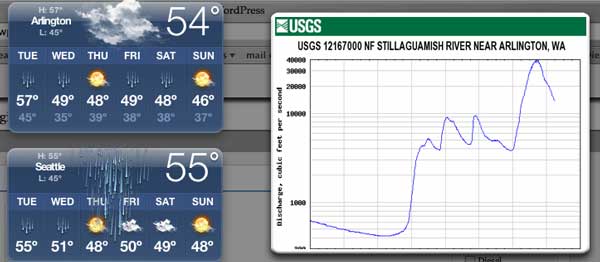
Above is a view of some of my OSX dashboard widgets. It looks like the weather will let up tomorrow. The USGS river widget is lacking some useful data, like a timescale or depth measurement! But it does show that the North Fork of the Stillaguamish is really moving (the scale is cubic feet per second). They have no measure near Arlington for the South Fork, which is the one that caused the road to close.
Oh well, I have my Internet access, my IP phone, and my family here, so we’ll be OK.
As my mom said to folks, about the nonexistent worry of being flooded out where we lived:
“If it gets this high…BUILD AN ARK!!”
Glad to hear ‘la familie Goolsbee’ is faring well…was a bit worried, what with I saw on the news…
No, we live far above the rivers Paul. I remember an old “Almost Live” skit from the late 80s… in the “John Report” he talked about the rivers here all being named like: Snohomish, Skykomish, Stillaguamish, etc and that in Coast Salish language the suffix “mish” meant “Floods every fall, build longhouse on hill”. 😉
–chuck